A Multi-Species/Habitat Ecological Evaluation of Alternative Everglades Restoration Plans
Authors
Frank J. Mazzotti, Leonard G. Pearlstine, Laura A. Brandt, Michelle P. Moller and Christa Zweig
Project Summary
Major goals of the South Florida Everglades Restoration Initiative are to restore and maintain the native biological diversity of South Florida, and to recover threatened and endangered species. Information on habitat and species distributions can be used to develop monitoring programs, develop models that predict amounts and locations of habitat types under different land use/management plans, and provide a base for the development of science-based conservation plans. The ability to model the potential effects of changes in land use allows us to decrease uncertainty when making management decisions.
Gap analysis has been developed as a landscape scale approach to biological diversity planning at the national scale. In Florida, it was recognized from the onset of the Gap Analysis Project that it could be used within the state to address ecosystem management issues in detail. Data layers completed to date in conjunction with the gap project include: a vegetation map of south Florida consisting of 70 vegetation types developed from 30m resolution 1993/94 satellite imagery, databases on habitat affinities of terrestrial mammals, breeding birds, wintering birds, reptiles, amphibians, ants, butterflies and skippers. These layers provide information that can be used to address questions on the current status of critical habitats, develop hypotheses on effects of different landscape configuration on future biological diversity, provide direction for development of restoration plans, and set priorities for restoration projects.
There are three objectives of this project
- Provide a comprehensive assessment of effects of restoration alternatives on the amount and configuration of ecosystem types and potential habitats of endangered and threatened vertebrates.
- Evaluate the effectiveness of threatened and endangered species habitat protection for protection of overall South Florida biological diversity.
- Provide a user friendly Arc View interface that can be used to display and query databases on potential habitats of terrestrial vertebrates, and present multiple layers in a format that is easily understood by policy makers.
The following example illustrates how these types of data layers can be used as a predictive tool for assessing changes in potential habitat for a single species, federally listed threatened and endangered (T & E) species, and a group of species (reptiles and amphibians). These methods also can be used as evaluation tools for different restoration alternatives and for prioritization of restoration of degraded natural communities.
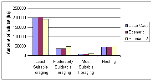
The Indian River Lagoon Restoration Feasibility Study area was selected as the scope for this example. Three scenarios are presented:
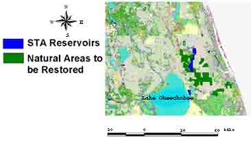
Base case- Conditions at the time of the land cover (199-1994)
Scenario 1- Inclusion of 10,500 ha of Stormwater Treatment Area Reservoirs (shown in blue)
Scenario 2- Inclusion of reservoirs and restoration of wetlands impacted by drainage activities.
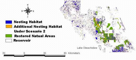
Base land cover in the project area with reservoirs shown in blue and natural areas to be restored shown in green.
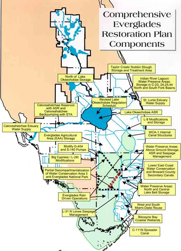
Several efforts are underway for restoration of the South Florida Ecosystem. Included in those are the Comprehensive Everglades Restoration Plan (CERP) under the direction of the U.S. Army Corps of Engineers and South Florida Water Management District, and the South Florida Multi-Species Recovery Plan (MSRP) coordinated by the US Fish and Wildlife Service.
To address complex issues of changes in land and water use, restoration efforts will have to be integrated across the entire region.
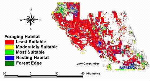
Sandhill cranes were used as the focal species. Cranes use both uplands and wetlands and are a good species for identifying where these linkages may be missing.
The model of potential habitat for Sandhill cranes is based on the relationship between appropriate nesting wetlands and foraging habitat (Pearlstine et al. 1999).
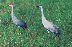
Potential habitat indicates areas where the species could occur based on county distribution, and on habitat affinity information gathered from the literature.
Location of CERP projects (left) and of Multi-Species Recovery Plan (right)
(Click for larger images)
Many CERP projects will benefit habitats and species that occur in the central wetlands core of the Everglades including snail kites, wood storks and crocodiles.
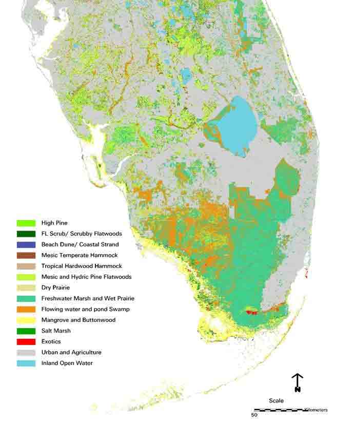
Land cover classification of South Florida-Data for classes were aggregated from the 70 classes of the Florida Gap Analysis Project land cover (Pearlstine et al. 2000) to match with the 23 habitats listed in the South Florida Multi-species recovery plan (U.S.Fish and Wildlife Service 1999).
Numerous data layers exist that can be used to develop tools for evaluating restoration plans that go beyond single species management and integrate habitats, species, communities and ecological integrity. These and other data layers will be integrated into an ArcView interface to provide a tool for evaluation of different development/restoration scenarios.
Examples of Data Layers
- Land cover
- Land use
- National Wetlands Inventory Data
- Critical Areas (Greenways, Florida Fish and Wildlife Conservation Commission Strategic Habitat Conservation Areas, Florida Natural Areas Inventory Scarce and Unique Habitats)
- Species Information (Potential Habitat Models, Element Occurrences, Breeding Bird Atlas)
- Water Bodies
- Proposed Projects
- Boundary Layers (SFWMD, Counties, Indicator Regions, Public Lands)
- Roads
 |
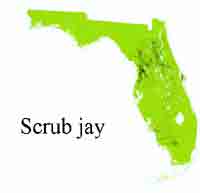 |
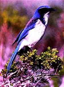
Restoration and protection of other species such as the scrub jay, caracara, and sand skink as well as upland habitats will need to be addressed through other efforts.
Potential crane habitat before (left) and after addition of reservoirs (Scenario 1) and restoration of wetlands (Scenario 2 - right).
(click for larger image)
Under Scenario 1 (not shown) approximately 150 ha of habitat was within the footprint of the reservoirs. Approximately 4,000 ha of nesting habitat was gained with the restoration of the natural areas.
Richness for federally listed threatened and endangered species (T & E) was calculated for the area encompassed by the crane nesting habitat Much of the area was identified as potential habitat for 2 to 5 T & E species.
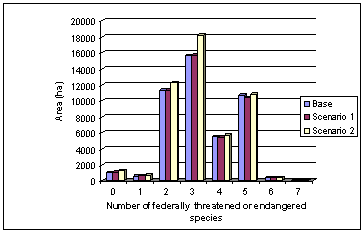
Areas of high species richness for one group (T & E species) may not be an indication of high richness for other groups.
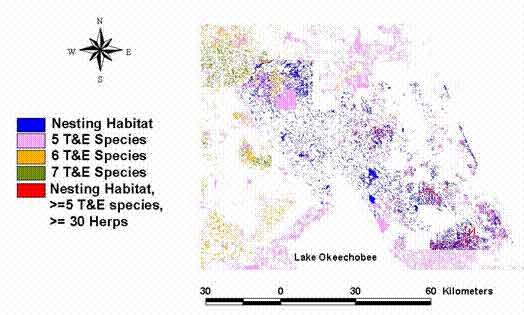
The map below shows areas of crane nesting habitat that have high richness for T & E species and high richness for reptiles and amphibians (herps). Areas in red are nesting habitat, potential habitat for a high number of T & E species and potential habitat for a high number of herps. Information like this can be used to prioritize protection and restoration of areas to benefit the greatest number of species.
- This project provides direct integration of South Florida-wide data layers on habitats and potential species developed through the USGS Gap Analysis and endangered species and the biological diversity of South Florida.
- It provides a scientifically based ecological evaluation procedure for assessing the potential effects of alternative restoration plans.
- It can be used to examine how restoration plans for one species might impact available potential habitat for other species, and for developing habitat management plans that optimize the benefits to the greatest number of species on a regional scale.
References
Pearlstine, L.G., L.A. Brandt, W.M. Kitchens, F.J. Mazzotti. 1995. Impacts of citrus development on habitat of southwest Florida. Conservation Biology 9(5):1020-1032.
Pearlstine, L.G., S. Smith, and W.M. Kitchens. 2000. Florida Gap Analysis Project. Final Report. U.S.G.S. Florida Cooperative Fish and Wildlife Research Unit. Gainesville, FL.
US Fish and Wildlife Service. 1999. South Florida Multi-Species Recovery Plan. Atlanta GA.
Acknowledgements
This project was supported in significant part by the Department of the Interior's Critical Ecosystem Studies Initiative, a special funding initiative for Everglades restoration administered by the National Park Service; and in part by USGS's Florida Caribbean Science Center and the US Fish and Wildlife Service.
Citation
Mazzotti, F.J., L.G. Pearlstine, L.A. Brandt, M.P. Moller and C. Zweig. (2001) A Multi-Species/Habitat Ecological Evaluation of Alternative Everglades Restoration Plans. Poster presented at the 28th Annual National Areas Association Conference. Cape Canaveral, FL.
More About This Project
A Multi-Species/Habitat Ecological Evaluation of Alternative Everglades Restoration Plan


