Integrating Urban Growth Models and Habitat Models for Ecological Evaluation of Landscape Impacts
Authors
Leonard G. Pearlstine, Frank J Mazzotti, Elise V. Pearlstine and Gareth Mann
An Urban Growth Model for South Florida
Regional restoration projects such as those in the Everglades and South Florida that attempt to restore ecological processes in natural areas can be impacted by urban and residential growth that is largely out of the domain of restoration scientists. It may be critical to the restoration decision process to understand potential landscape impacts of urban growth on the success of proposed restoration scenarios. Initial trials are being tested on Martin and Palm Beach Counties on the east coast of Florida where urban development is moving west into currently agricultural land uses.
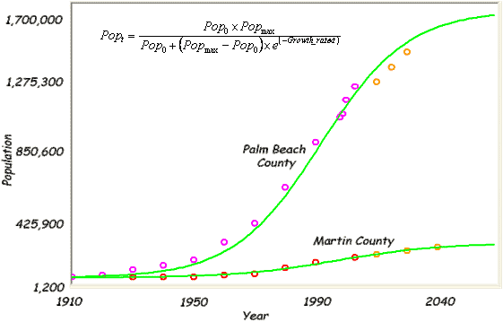
A logistic growth model was fitted to population growth data for the two counties. The spatial location of growth was then modeled based on calibrated probabilities for:
- Distance to Urban
- Distance to Roads
- Distance to Water
- Ratio of Surrounding Area that is Urban
- Random New Development
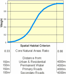
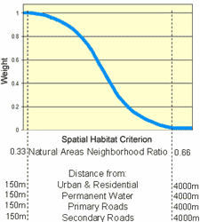
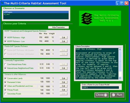
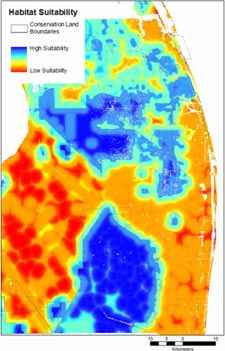
Multi-Criteria Habitat Evaluation
Landscape habitat changes are evaluated using potential habitat models for all terrestrial vertebrates in the region and all threatened and endangered species. Spatially-explicit measures of species richness, community fragmentation, and proximity to landscape features are weighted in a multi-criteria habitat assessment against changes in land use predicted by the urban growth model. The graphs on the left show the user adjustable weightings applied to criteria currently available.
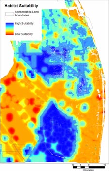
Application to the Everglades Agricultural Area
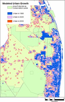
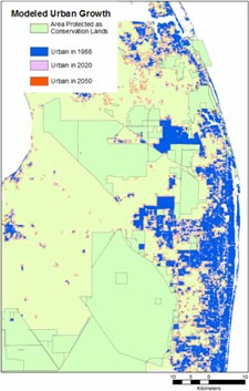
Two alternative simulations are shown here for 70 year runs from 1989 to 2058. Starting with known land use in 1989 allows us to validate spatial growth predictions against known land use in 1999 and 2003 and then continue on into the future. The criteria used for habitat evaluation in each of the alternatives were proximity to areas of high listed species richness; proximity to areas with lower, but still present, listed species habitat; proportion of natural area within a 800 m neighborhood; and proximity to urban and residential areas. The high listed species richness criterion was given twice the weight of the other criteria. The first alternative models the spatial distribution of growth using average population density in each county. The second alternative assumes that population densities will be doubled as part of a growth management objective to reduce westward urban sprawl into the current agricultural areas.
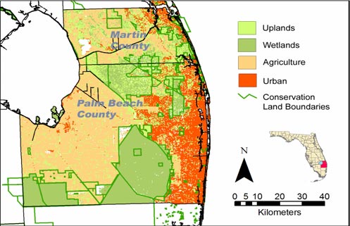
Land use from a 2003 classification; Florida Fish and Wildlife Conservation Commission.
Urban Growth with Spatial Distributions Based on Doubling Population Densities
Development in this alternative tightly hugs existing urban centers leaving broader, more connected natural areas along the east coast and more manageable growth along roads in the Everglades Agricultural Area. Habitat suitability scores are higher outside of conservation areas, though still generally low. High habitat suitability scores extend out from the conservation areas to a further extent than before and there are more pockets of high suitability.
Urban Growth with Spatial Distributions Based on Current Population Densities
Development has expanded to fill in most of the natural areas remaining along the east coast, particularly in Palm Beach County which has a higher expected growth rate than Martin County. In the Everglades Agricultural Area, new growth has created an unstructured pox of urban/residential centers. Little suitable habitat remains outside of the managed conservation areas.
Improvements
This poster presents early results of integrating urban modeling and ecological evaluations. There is considerable room for improvement of the growth model assumptions and refinement of the ecological evaluations. An important addition would be a landscape connectivity metric of fragmentation impacts on faunal movement among resource patches. It will also be important to recognize that agricultural lands have value for forage, cover, and movement.
Citation
Pearlstine, L.G., F.J. Mazzotti, E.V. Pearlstine and G. Mann. (2004, December). Integrating Urban Growth Models and Habitat Models for Ecological Evaluation of Landscape Impacts. Poster presented at the National Conference on Ecosystem Restoration, Orlando, Florida.


