An Application of EDEN
Application of the Everglades Depth Estimation Network (EDEN) to Monitoring and Restoration
Authors
Philip M. Heidemann, Bryan Botson, Leonard Pearlstine, ZongBo Shang, Rachael Harris, Dale E. Gawlik, Frank Mazzotti and Aaron Higer
EDEN data could be used by investigators to:
- Quickly identify sites that are at the proper water depths for biological sampling, thus increasing sampling efficiency.
- Develop statistical models that describe the relationship between hydrologic variables and biological response variables.
- Drive existing spatially-explicit landscape suitability indices, which would provide real-time assessment of habitat conditions for selected species.
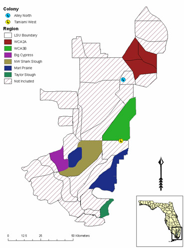
Figure 1. Colored areas represent LSUs for which field transect depth data were compared with EDEN depth estimates. Transects were run from 10 January through 23 May 2005. The wading bird icons indicate locations of colonies that experienced significant nest abandonment during the 2005 breeding season.
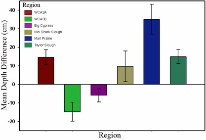
Figure 2. Mean depth difference and SE (transect minus EDEN) by region.
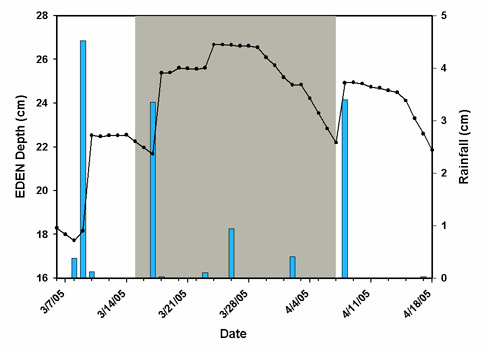
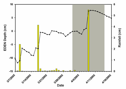
Figure 3 and 4. EDEN depth estimates, local rainfall amounts, and approximate date range of nest abandonment at the Alley North and Tamiami West wading bird colonies. Colored bars represent local rainfall amounts; the shaded area represents the approximate date range of nest abandonment.
Water Depth Comparison
- Mean field depths exceeded EDEN estimates in 4 of 6 regions.
- The Big Cypress region had both the lowest mean depth difference (-6.0 cm) and the lowest SE (3.6).
- The Marl Prairie region had the highest depth difference (35.0 cm) and the second highest SE (8.1).
Detection of Reversals
- Increases in depth reported by EDEN were similar in magnitude to the amount of rain recorded at local gauges.
- EDEN immediately responded to the rain events of 9 March, 17 March, and 8 April 2005.
- EDEN appears to be sensitive enough to detect reversals in water recession which are often followed by nest abandonment.
- Due to the significant difference between field-measured and EDEN depths EDEN is probably not yet useful for identifying areas of the Everglades that are suitable for biological sampling.
- If variability is low, such as in Big Cypress and Taylor Slough, it may be possible to correct for this difference and obtain more accurate predictions.
- Currently EDEN may be more appropriate for developing hydrological models that relate to biological responses and habitat suitability index models that rely on depth changes rather than actual depths.
Citation
Heidemann, Philip M., Bryan Botson, Leonard Pearlstine, ZongBo Shang, Rachael Harris, Dale E. Gawlik, Frank Mazzotti and Aaron Higer. (2006, June). An Application of EDEN: Application of the Everglades Depth Estimation Network (EDEN) to Monitoring and Restoration. Poster presented at the Greater Everglades Ecosystem Restoration Conference, Orlando, Florida.


