Decision Models and Directions for the South West Florida Feasibility Study
Authors
Leonard G. Pearlstine, Frank J Mazzotti, Tomma K. Barnes, Mike Duever, Debbie Irvine, and Donald L. DeAngelis
Introduction
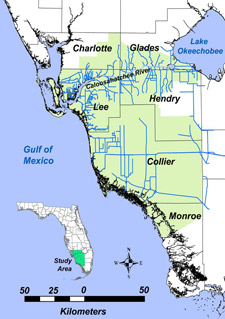
The objective of the Southwest Florida Feasibility Study (SWFFS) is to develop a comprehensive, ecologically sound regional plan for water resources in a 4,300 square mile area west of the Everglades (Figure 1). The study was recommended because of (1) water supply and ecological issues with water releases from Lake Okeechobee to the Caloosahatchee River, and because (2) inland hydrologic alterations have substantial existing and potential effects on rich natural resources and biodiversity. Spatial decision support systems (SDSS) for natural resource management are computer-based tools that tightly integrate decision theory models with ecological models and geographic information systems (GIS) analyses and mapping. The information that SDSS provides gives decision-makers increased ability to follow outcomes of interacting variables, improves the reproducibility of decisions and documents why, with conflicting alternatives, a particular choice was made.
Landscape level decision-making involves multiple objectives, large data sets, and many unknowns and uncertainties.
Developments to support this process include:
- Regional habitat evaluations of stressors to coastal and
- Inland ecological systems and decision aids for the evaluation of alternative water management and land use scenarios.
 |
 |
| Figure 1. Study Area |
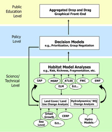
Figure 2. Hierarchical spatial decision support system. Abbreviations represent current habitat models in southern and southwestern Florida. |
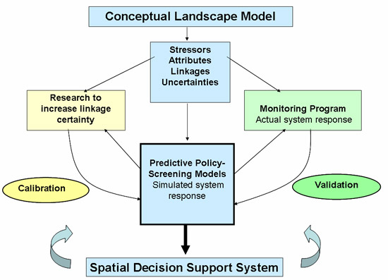
Figure 3. An adaptive management, decision support process
Decision Support of Landscape Habitat Evaluation
Different, but integrated tools assist decision making at the level of the scientist, the policy maker, and the public (Figure 2). Decision aids assist the scientist in evaluating what criteria best define performance measures for ecological evaluation and what value those criteria will have with a particular management action. Models predict changes in the physical environment from alternative actions and their effect on wildlife habitat and ecological communities. At the policy level, decision models rank and aid decisions among criteria and alternative management actions. Evaluations of alternatives at this level may lead to modified or new options, which would then be returned to scientists for evaluation, using the previous support tools. At the level of public participation, a graphical, public education version of the decision process can increase public understanding of conservation management actions, create a sense of involvement and "ownership" in decisions, and alert policy makers and resource managers to social judgments of alternative plans.
The decision process starts with conceptual models to identify ecological stressors in the region, what measurable criteria can be used to evaluate effects of alternative management actions, and what those management actions might be. Predictive models and policy decision support tools result in the implementation of a management action. Upon implementation, monitoring provides feedback of actual ecological responses and directed research attempts to address uncertainties in the models. This information is used in a continuous adaptive management cycle for incrementally improving the ecological models and conservation management actions being implemented (Figure 3).
Southwest Florida Ecological Evaluations
Coastal Species Evaluations
- American Oyster
- Blue Crab
- Spotted Sea Trout
- Sea Grasses (Halodule & Thalassia)
- Freshwater Grass (Vallisneria)
- zooplankton
Inland Species Evaluations
- Long-legged Wading Birds
- Short-legged Wading Birds
- Amphibians
- Aquatic fauna
Inland Community Evaluations
- Modeled hydrological suitability measures of indicator regions
- Threatened & endangered species richness
- Overall vertebrate species richness
- Proximity to landscape features
- Community fragmentation
Inland Landscape Evaluations
- How landscape elements such as habitat, edges, and contiguity affect movement and usage of the landscape by wide-ranging mammals (Florida Panther, Black Bear, and Bobcat).
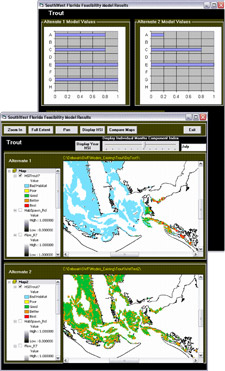
(Figure 4 shows output from a species habitat model for spotted sea trout at the mouth of the Caloosahatchee River.)
Decision models
Decision models integrate results of ecological models to allow collective evaluation of habitat change and for decisions to be from multiple evaluations. Figure 5 illustrates a multi-criteria decision support interface that spatially models ecological suitability of management plans based on user-selected and user-weighted criteria. Decision tools and graphical methods help provide a critical examination of the process of defining issues, proposing alternative solutions, and developing measurable criteria for evaluating the performance of each alternative.
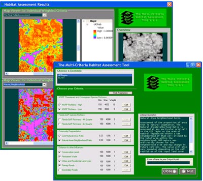
Figure 5. Multi-criteria decision support interface for habitat evaluations.
Citation
Pearlstine, L.G., F.J. Mazzotti, T.K. Barnes, M. Duever, D. Irvine, and D.L. DeAngelis. (2004, December). Decision Models and Directions for the South West Florida Feasibility Study. Poster presented at the National Conference on Ecosystem Restoration, Orlando, Florida.
More About This Project
Technical Assistance for an Ecological Evaluation of the Southwest Florida Feasibility Study


